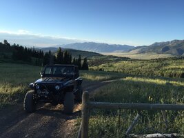
That is the tallest stinger I’ve ever seen!
You are using an out of date browser. It may not display this or other websites correctly.
You should upgrade or use an alternative browser.
You should upgrade or use an alternative browser.
TJs in beautiful places
- Thread starter glwood
- Start date
deserteagle56
Member
At Kyle Hot Springs, northern Nevada:
View attachment 518076
So Kyle is some dude who set a tub of water out in the sun?
deserteagle56
Member
So Kyle is some dude who set a tub of water out in the sun?
No idea where the name came from. But the hot springs (Nevada is covered with them) are all artesian and most too hot (boiling water) so the water is piped a ways till it cools off and then goes into tubs. So to keep idiots safe the hot springs themselves are generally fenced off.
This is a pic of the source of Kyle Hot Springs:
Most of Nevada's hot springs are on public land so anyone can jump in. Since many are pretty remote it's likely you'll have them all to yourself:
The different tubs are for different temperatures...warm to really hot!
This is Double Hot Springs at the edge of the Black Rock Desert. Wagon trains heading for California used to stop here...to cook their beans!
Today the government has put up warning signs because people have jumped in and died...
Some of Nevada's hot springs put out enough steam that they are used to provide electrical power:
Bobsled84790
Member
deadbeat son
TJ Addict
deserteagle56
Member
Coming down out of Nevada's Pine Nut Mountains yesterday afternoon:

Puerto Lobos, on the Sea of Cortez, Sonora, Mexico. The cliffs are packed sand, earth & rocks and you can see the water lines where high tide hits and each time crumbles away more of the cliffs. Over the years it has washed away the earth leaving a layer of small stones rounded by the constant daily pummeling of the sea that in places are 3 feet or more deep making for a lot of resistance on the tires, had to air down and use 4LO. The stones get smaller as you get closer to the water and eventually turn into sand that can be seen in some areas at low tide. The cliffs run for miles but when the tide is coming in you'd better be out of there. I went out about 2 miles at low tide then turned back. In the first pic you can see the tiny fishing village of Puerto Lobos about a mile away.


Last edited:
Where in New Mexico is all this? Amazing.
Where in New Mexico is all this? Amazing.
Thanks! It's Northern NM, West side of Rio Grande near Taos. Sometimes called Taos Plateau. Huge area where you almost never see anybody else. You do see bighorn sheep, pronghorn antelope, elk, an otter once, etc. Fun area to explore.
Thanks! It's Northern NM, West side of Rio Grande near Taos. Sometimes called Taos Plateau. Huge area where you almost never see anybody else. You do see bighorn sheep, pronghorn antelope, elk, an otter once, etc. Fun area to explore.
Thanks very much for this. I've only ever seen New Mexico from Interstates 10, 25 (Raton to Albuquerque section), and 40.
All of it was really nice, but the stretch from Raton to Albuquerque was definitely my favorite.
I'd love to end up out in the southwest where views like this are within reach. Thanks very much for sharing!
Coming down out of Nevada's Pine Nut Mountains yesterday afternoon:
View attachment 520379
I don't think I've ever seen a white on white TJ. She looks amazing, contrasting against the semi-arid landscape around her!
Thanks! It's Northern NM, West side of Rio Grande near Taos. Sometimes called Taos Plateau. Huge area where you almost never see anybody else. You do see bighorn sheep, pronghorn antelope, elk, an otter once, etc. Fun area to explore.
I try to go there twice a year. My great grandparents were in Chacon, Great Grandpa used to go from Chacon to Trinidad through Raton Pass to get supplies in wagons. On my great grandma's side they lived all along the Gallinas River Valley from Las Vegas to Trementina, a lot of the ruins are still standing.
Before moving to NM, I honestly didn't know that much about it. I like to say it's sorta under the radar. We had flown in/out of the ABQ airport many times but we were always on our way to somewhere else like SE Utah or SW Colorado. We wanted to be near 4 corners but have amenities like hospitals and an airport so we ended up near Albuquerque.
We like it. Great weather. No grass to mow or snow to shovel. A day's drive to all sorts of amazing places. And endless exploring opportunities within a couple hours or less. And the views from home are pretty decent too.
We like it. Great weather. No grass to mow or snow to shovel. A day's drive to all sorts of amazing places. And endless exploring opportunities within a couple hours or less. And the views from home are pretty decent too.


