It is truly fun. I would say the best trail I've been on. Recently given a badge of Horror (err honor) trail. The incredibly modern airstrip (jet capable) will sell gas rather than going down to the Rec area. Here's some advice and info....
Plan to be out 5 nights minimum. 1st and 5th night are at the beginning of trail. 2nd, 3rd, & 4th night should be off of and west of Gray Mesa. One day for the Rincon and one day for the Chute and Cottonwood Canyon. If you're an animal, hike to Register Rock and back. Top up at airstrip if you can. Carry another 7 gallons of gas. 10 is better. Rip out the stupid console and put a small fridge there. Be sure you can still operate the Ebrake.
1) 7500 foot Airstrip. Could be longer. 1A) Recommended entry and exit
2) Old entry to Lake Canyon now closed due to massive flood around 2006. I got to do this back in 2004 in my XJ! The new route swings around south to meet up with the eventual ascent to Gray Mesa. Can backtrack to Lake Canyon if you want...take another day.
3) Gray Mesa and San Juan River Overlook. Cell tower is on top of Navajo Mountain to the south.. great coverage.
4) To the left of the number you can make out the impressions of the Chute. It's not nearly as bad as Hell's Gate on Hell's Revenge.
5) End of trail at beginning of Cottonwood Canyon. you can see Lake Powell 3 miles down canyon.
6) The Rincon, now open. Have not done that...Who wants to meet me for a trip?
7) Hole in the Rock on west side; Register Rock on east side.
View attachment 243522
Detail of second finger of Lake Canyon crossing...I'm so lucky I got to do that.
1) Note the carve out in the rock cliff. That's the road and the very same trail the Mormons cut out of the rock.
2) The other side of the canyon.
View attachment 243534
North end of Gray Mesa. Note the road appears to be a scratch.
View attachment 243535
Below is a detail of above circled terrain and the approximately 1000 ft ascent to the mesa.
1) is where I had to be strapped by a so called clunker XJ. The JLUR and Gladiator Rubicon with us also made it just fine. There was a group of Lexus GXs we couldn't keep up with. Also, a built Ford F 250 hauling a ton of boxed gear and supplies in for a survey crew somewhere.
2) The blue line is the original Mormon route. Note the cutouts. They tried multiple routes, and often lowered mules, livestock and wagons by slings. The carve out at 2 wasn't more than 6 ft wide if that in places. The wagons were very narrow. The trails very steep.
A to B is about a 1000 foot ascent.
View attachment 243536
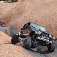
Below is from my trip of 2004. It's steeper than the photo shows. This is beyond the Chute between the Chute and end of the trail at top of Cottonwood Canyon.
View attachment 243539
I would rate this a 3.75 out of 5 in difficulty. It will bankrupt you if you have trouble or run out of gas deep in.










 , poor kids in a tent. Just kidding...
 of my life!